"I'm the map, I'm the map, I'm the map, I'm the map, I'm the map!" - The Map
This article will teach you all about using Exterior Location Plans. SignAgent is integrated with an exterior mapping service called MapBox, which allows us to display street maps and satellite maps within the SignAgent system.
Unlike uploaded documents, external maps require an internet connection to load in the mobile app.
1. How to Add Exterior Locations

- Select: Wrench in the Locations area of the sidebar
- Choose: New Location
- Name of the Location
- Short code
- Type in your location in Location Search bar.
(Note that this can be an address, landmark, city, country, or other location) - Select: Save & Close
- Note that as you type into the Location Search, the system will try to auto-complete a full address for your new location. Continue typing until the auto-completed address below the bar matches the area you're looking for.
- You can also Right-click on any Folder in the Location Structure to add a new location to that folder.
2. Using Exterior Locations
You can use exterior plans almost exactly the same way you use normal plans. You can add signs by right-clicking, move around the location plans by clicking and dragging on the plan, zoom in and out with the mouse-wheel or plus or minus buttons.
A couple of things that are different:
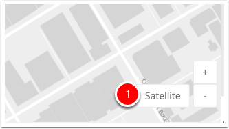
- You can switch from street view to satellite view (and back) by clicking where it says "Satellite" and "Street" in the bottom-right corner
- When exporting exterior plans, the zoom level will be dependent on where your signs are placed. So, if you place your signs around a city block, it will export the city block. If you export around the city, it will export the whole city.
- When adding signs, you'll see that it automatically adds a latitude and longitude coordinate to your sign, based on its placement. You can enter these coordinates in manually, if you'd prefer, and they will be included in any Excel Exports that you do.
Note that all street and satellite views are dependent on MapBox's data, and will display whatever is most current in their system. SignAgent does not have control over this, and will be unable to make any changes to these maps directly.
We've reached out to other major mapping providers (Google, Apple, etc), but were unable to reach an agreement with them to use their mapping data.